 English
  Français
  Español
 Steffen Oppel (Royal Society for the Protection of Birds, UK) and colleagues in press with the journal Biological Conservation have looked at how computer modelling can help predict the distribution of Balearic Shearwaters Puffinus mauretanicus along the Portuguese and Spanish Atlantic coasts from ship-transect data.
The paper's abstract follows:
"Knowledge about the spatial distribution of seabirds at sea is important for conservation. During marine conservation planning, logistical constraints preclude seabird surveys covering the complete area of interest and spatial distribution of seabirds is frequently inferred from predictive statistical models. Increasingly complex models are available to relate the distribution and abundance of pelagic seabirds to environmental variables, but a comparison of their usefulness for delineating protected areas for seabirds is lacking. Here we compare the performance of five modelling techniques (generalised linear models, generalised additive models, Random Forest, boosted regression trees, and maximum entropy) to predict the distribution of Balearic Shearwaters (Puffinus mauretanicus) along the coast of the western Iberian Peninsula. We used ship transect data from 2004 to 2009 and 13 environmental variables to predict occurrence and density, and evaluated predictive performance of all models using spatially segregated test data. Predicted distribution varied among the different models, although predictive performance varied little. An ensemble prediction that combined results from all five techniques was robust and confirmed the existence of marine important bird areas for Balearic Shearwaters in Portugal and Spain. Our predictions suggested additional areas that would be of high priority for conservation and could be proposed as protected areas. Abundance data were extremely difficult to predict, and none of five modelling techniques provided a reliable prediction of spatial patterns. We advocate the use of ensemble modelling that combines the output of several methods to predict the spatial distribution of seabirds, and use these predictions to target separate surveys assessing the abundance of seabirds in areas of regular use."
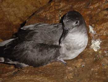
Balearic Shearwater. Photograph by Daniel Oro
Reference:
Oppel, S., Meirinho, A., Ramírez, I., Gardner, B., O'Connell, A.F., Miller, P.I. & Louzao, M. 2012. Comparison of five modelling techniques to predict the spatial distribution and abundance of seabirds. Biological Conservation in press.
John Cooper, ACAP Information Officer, 11 April 2012