 English
  Français
  Español
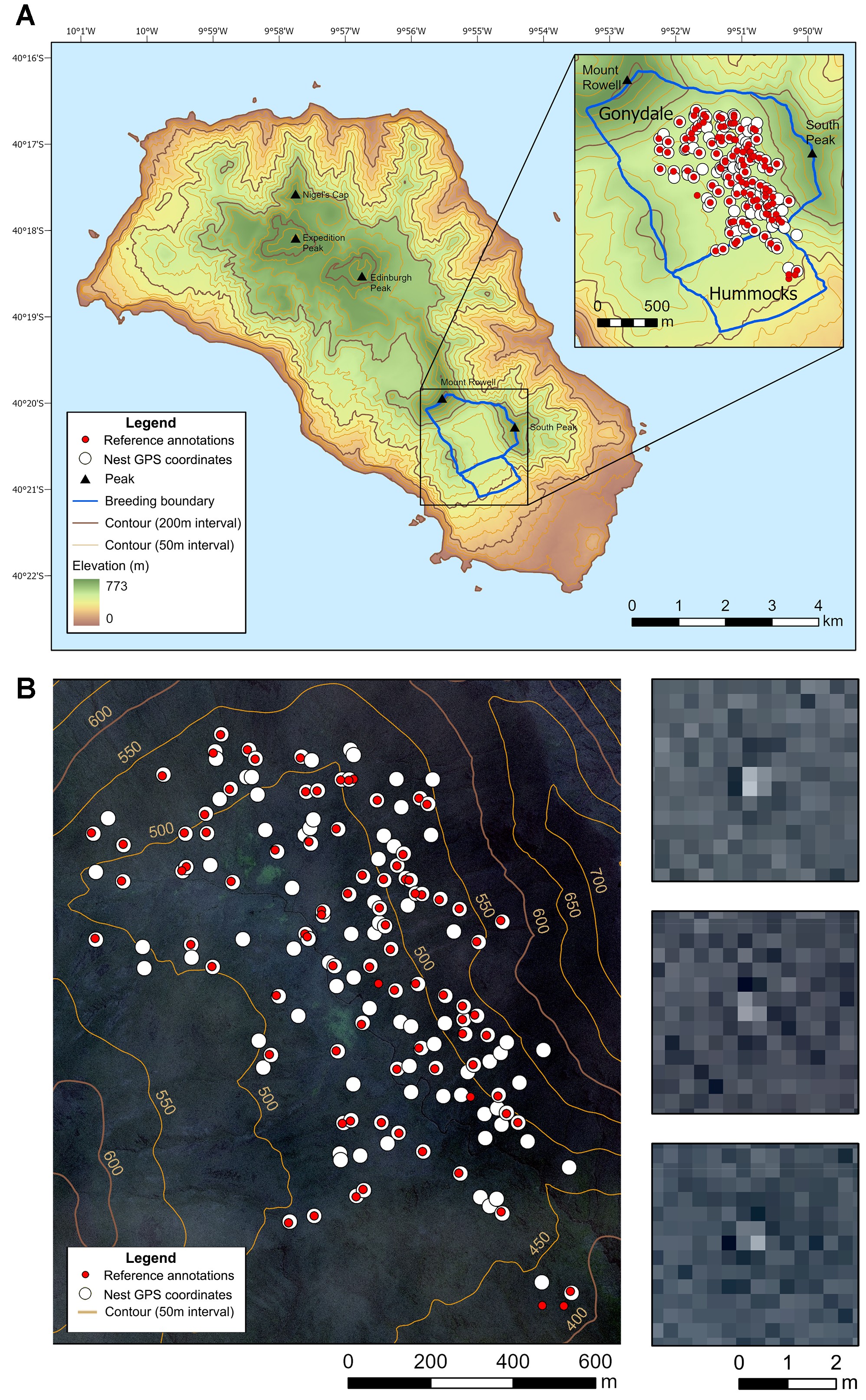
(A) Map of Gough Island and relevant features, with an inset map of the 2 study areas (Gonydale and Hummocks) that were cloud-free in the satellite image. (B) Satellite image (33 cm resolution downsampled to 30 cm resolution) showing GPS coordinates of Tristan albatross nests from ground surveys in 2018, and nests and presumed non-breeders observed in imagery. Three random examples from the satellite image shows an individual nesting Tristan albatross as light pixels in the centre of the panel (from the publication)
Marie Attard (British Antarctic Survey, Cambridge, UK) and colleagues have published in access in the journal Endangered Species Research on attempting to monitor Critically Endangered Tristan Albatross Diomedea dabbenena using satellite imagery.
The paper’s abstract follows:
“The Tristan albatross Diomedea dabbenena is a Critically Endangered species that breeds exclusively on remote islands in the South Atlantic Ocean. Although the population continues to decline, regular on-the-ground monitoring of Tristan albatross populations is logistically challenging and costly. If this monitoring is reduced in the future, then alternative methods would be necessary to track long-term population trends. Here, we assessed the viability of using 31 cm resolution satellite imagery to count Tristan albatrosses during the breeding season on Gough Island. Counts of birds in a satellite image by 2 wildlife remote-sensing specialists were compared with GPS coordinates of active nests recorded in the field. Birds were detected at 103 (67.8%) of the 152 active nests in the cloud-free regions of the satellite image. Acquiring suitable imagery is challenging because upland nesting sites are prone to low-lying orographic cloud, with only 1 cloud-free image obtained across 8 seasons of archived and 1 yr of tasked imagery. Our research demonstrates that due to incomplete detection, and the limited availability of suitable imagery resulting from persistent cloud cover over the island, Tristan albatrosses cannot be reliably counted or monitored with available satellite imagery. Differences in detection probability were not explained by nest attributes or bird plumage colouration. More commercial satellites in orbit may improve chances of obtaining cloud-free imagery across the island in the future, but until then, on-the-ground monitoring is required if we are to obtain accurate population counts and for the UK to meet its commitments to monitor this species.”
With thanks to Richard Phillips, Britih Antarctic Survey.
Reference:
Attard, M.R.G., Phillips, R.A., Oppel, S., Bowler, E. & Fretwell, P.T. 2025. Feasibility of using very high-resolution satellite imagery to monitor Tristan albatrosses Diomedea dabbenena on Gough Island. Endangered Species Research 56: 187-199.
John Cooper, Emeritus Information Officer, Agreement on the Conservation of Albatrosses and Petrels, 11 April 2025